America’s urban wildfire crisis:
More than 1,100 communities at risk
More than 1,100 communities in 32 states face similar risks to Los Angeles and other places with recent urban wildfires, highlighting the urgent need for wildfire-resistant homes and neighborhoods.
While the recent fires in Los Angeles were shocking, hundreds of communities across the United States—including in Florida, Oklahoma, and Alabama—are ripe for a similar scenario. Because it’s important to take action and prepare for these urban wildfires, Headwaters Economics has created an interactive map that shows which communities have risk factors comparable to Los Angeles.
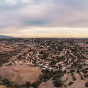
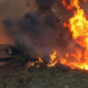
The fires in Los Angeles follow a pattern starting to become familiar. As was seen in Hawaii’s Lahaina Fire, Colorado’s Marshall Fire, and Oregon’s Almeda Fire, wind-driven embers from nearby wildfires ignited homes, which spread fire rapidly to neighboring homes, becoming an urban conflagration. Also known as urban wildfires, these large, difficult-to-control fires may start as wildfires but, upon entering communities, buildings become the source of fuel. It is the building-to-building transmission that causes widespread destruction that can occur in communities of any size.
Wildfires that become urban conflagrations are becoming more frequent and damaging, with some of the most destructive occurring in the past decade. The communities that faced these disasters all shared key risk factors: high likelihood of wildfire on adjacent lands and many homes exposed. When extreme winds enter the equation, the number of burning buildings quickly overwhelms firefighting resources.
Hundreds of places have a wildfire risk profile similar to Los Angeles
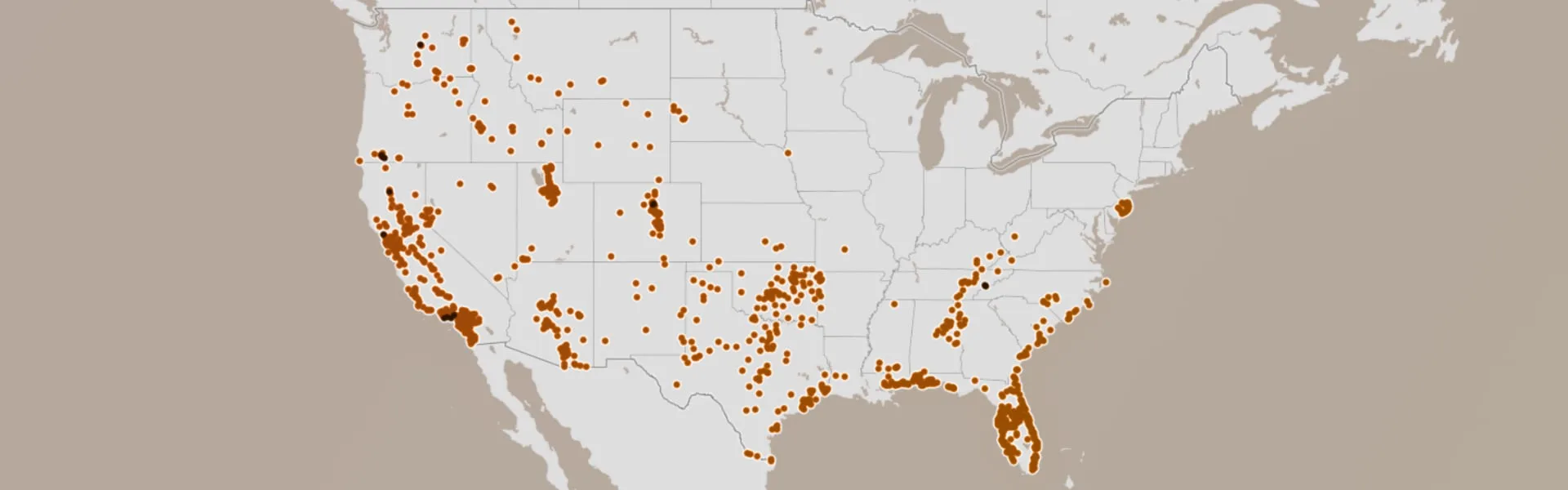
Using data from the U.S. Forest Service’s Wildfire Risk to Communities project, Headwaters Economics examined the risk markers in communities with recent urban wildfires to identify communities that share similar characteristics. There is no way to precisely predict the next disaster, but this analysis shows that more than 1,100 communities in 32 states across the United States share similarities with communities recently devastated by urban wildfires.
The map below shows locations that share two of the most significant risk factors of recent urban wildfires: a higher likelihood of nearby wildfire and a higher potential for home loss—even with top-notch firefighting resources. (See Methods & Data Sources below).
Look up your community’s wildfire risk
These communities were identified by examining the shared characteristics of recent urban wildfires and other U.S. communities. As with the map above, the orange dots on the graph below represent communities with the greatest potential for wildfires becoming urban conflagrations. The brown dots represent communities that already faced recent urban wildfire disasters.
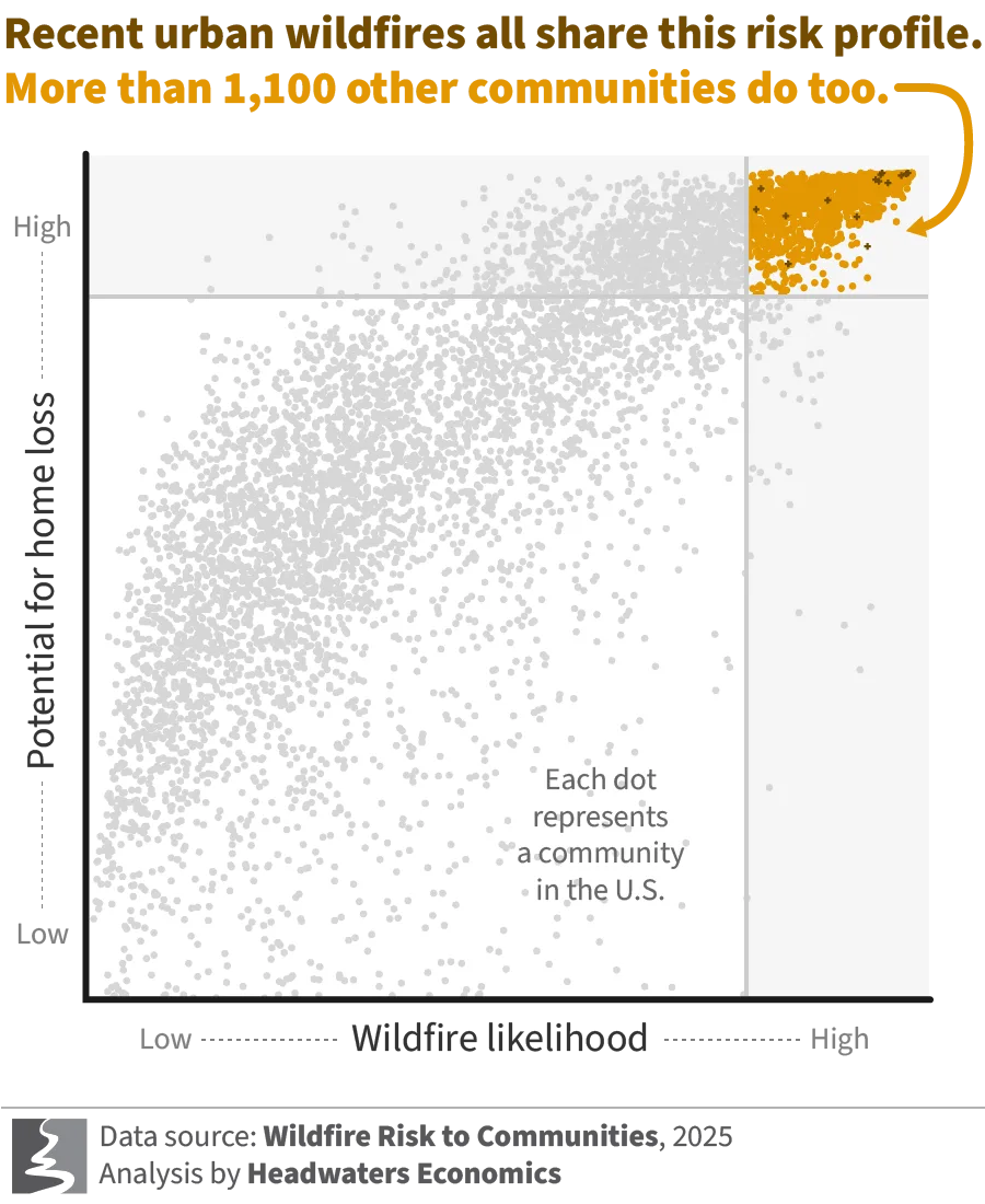
The characteristics captured in this analysis are not the only measures of risk. Community leaders and fire personnel also need to weigh local risk factors, such as wind conditions, ignition sources and locations, fuel moisture, firefighting resources, housing arrangement, and building design and construction, which affect every community’s risk. Additionally, wildfire risk modelers are still working to accurately represent mechanisms of ember spread and home-to-home fire ignition in risk maps. Even with these limitations, this analysis can help identify communities where risk is higher.
Urban wildfires don’t just happen in the West
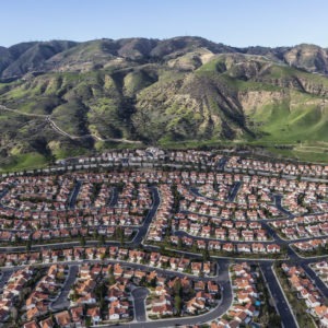
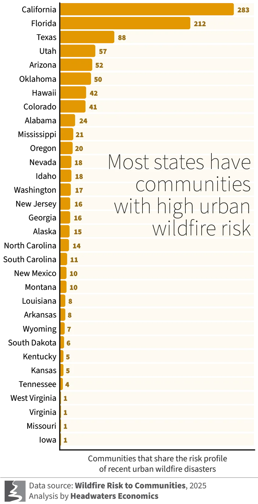
Although many might assume urban wildfire risk is limited to forested areas in western states, this analysis indicates that more than half (52%) of the communities with the greatest potential for catastrophic events are not in the West. Florida, Texas, Oklahoma, and Alabama are among the top 10 states when ranked by communities with high urban wildfire risk factors.
In Texas and Oklahoma, the potential for fast-moving grass fires and extremely strong winds puts thousands of homes at risk. In Florida, Georgia, and Alabama, dense vegetation exposed to dry periods and frequent lightning and human ignitions set the stage for disaster in highly populated areas. In dozens of states, rapid housing development in areas with flammable vegetation contributes to rising risk.
Subscribe to our newsletter!
Communities should prepare for urban wildfire now
Many well-researched actions can help reduce community wildfire risk, but they require a shift in local, state and federal approaches to wildfire management. Beyond fire suppression and vegetation management, construction of wildfire-resistant homes, neighborhoods, and communities must also be prioritized.
A focus on the built environment helps address the fundamental causes of disasters like those in Los Angeles. Urban conflagrations often begin with windblown embers flying ahead of a wildfire front, igniting spot fires that expose homes to flames and heat. The speed at which a spot fire becomes an urban conflagration can be influenced by construction materials, landscaping, and the proximity of homes to each other. Building and retrofitting homes and neighborhoods to minimize places where embers can ignite is not only necessary, research has found it can be practical and cost-effective. Reducing wildfire risk communitywide can also help keep insurance markets accessible and potentially avoid billions in disaster recovery costs that often fall on taxpayers.
The human and economic devastation in Los Angeles is a stark warning of what could happen to communities with similar risk across the country. Investing in wildfire-resistant homes and communities today will save lives, homes, and economic losses in the future. Communities must prepare now to prevent the next disaster.
Explore your local wildfire risk and take steps to reduce your risk with free resources.
Methods & Data Sources
First, we identified the largest urban conflagrations in the last 10 years and the communities they damaged. Each fire included in the sample burned more than 500 structures. Fires and impacted communities included in the analysis were:
- Almeda Drive Fire (2020): Ashland, Medford, and Talent, OR
- Camp Fire (2018): Paradise, CA
- Carr Fire (2018): Redding, CA
- Chimney Tops 2 Fire (2016): Pigeon Forge and Gatlinburg, TN
- Eaton Fire (2025): Altadena, CA
- Lahaina Fire (2023): Lahaina, HI
- Marshall Fire (2022): Superior and Louisville, CO
- Palisades Fire (2025): Los Angeles, Malibu, and Topanga, CA
- Sleepy Hollow Fire (2015): Wenatchee, WA
- Tubbs Fire (2017): Santa Rosa, CA
We then compared the suite of risk variables available from the Wildfire Risk to Communities dataset (see Dillon et al., 2024) in the locations with urban conflagrations. All locations with urban conflagrations had the following risk characteristics:
- Potential for home loss (also called Expected Annual Housing Unit Risk) exceeded the 85th percentile nationally. This is a measure of the expected damage to, or loss of, housing units due to wildfire in a year.
- Wildfire likelihood (also called Burn Probability) exceeded the 80th percentile nationally. Wildfire likelihood is the probability of a wildfire occurring and is summarized for an area 1.5 miles (2.4 kilometers) beyond the community boundary, which can help account for the possibility of embers traveling from nearby vegetated areas into residential neighborhoods.
Finally, we identified communities that met the above two risk characteristics and that had at least 2,500 housing units.
Limitations of this analysis
This analysis represents a summary based on the characteristics of previous urban conflagrations and nationally consistent data summarized to the community level. Local factors—including extreme weather, housing arrangement, and firefighting resources—also influence risk. Therefore, this analysis could over- or under-estimate risk for some communities. The analysis does not provide data for prioritizing neighborhood-specific actions. It also does not account for areas outside of Census-designated communities. Inclusion in the map shown here does not guarantee a disaster will occur; exclusion does not imply the absence of risk.