Updated April 2026
More than 132,400 structures have been destroyed by wildfires since 2005, resulting in an untold number of fatalities, evacuations, and injuries. The number of structures destroyed by wildfires, rather than the number of acres burned, is a more telling measure of the broad social, economic, and community impacts of wildfires.
Wildfire structure losses are increasing
The number of structures destroyed by wildfires accurately represents the increasing devastation and impact at the community level. While much attention is given to the size of a fire (acreage burned), this statistic fails to capture the true effects on people, neighborhoods, and communities. More telling numbers include the number of homes lost, people evacuated, and human fatalities.
As wildfires increase in severity, frequency, and duration, they are becoming more damaging and costlier. While vast sums of money are spent protecting homes and communities from wildfires, not enough money is invested in upfront planning to make neighborhoods more resilient to increasing risks.
Since 2005, wildfires have destroyed more than 132,400 homes, businesses, and other structures.
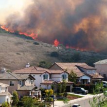
Wildfires are more common in the West, but they are widespread across the country and nearly every state has experienced structure losses as a result. California has by far endured the most structure losses over time, yet no state is immune to wildfire, as evidenced by recent conflagrations in Texas, Hawaii, Oklahoma, Florida, Colorado, and Tennessee.


Community Planning Assistance for Wildfire
Community Planning Assistance for Wildfire (CPAW) works with communities to reduce wildfire risk through improved land use planning. The program is a program of Headwaters Economics, in partnership with the USDA Forest Service.
A better measure of wildfire impacts
For too long, acres burned has been the primary measure of a wildfire’s impact. And while important from an operational perspective, this figure falls short of measuring the diverse social, economic, health, and psychological impacts of wildfires.
Moreover, focusing exclusively on the size of wildfire overlooks the important ecological benefits of wildfire. Large, low-severity wildfires burning where there are no homes can rejuvenate forests and replenish soils, while small, high-severity wildfires that escape mitigation and suppression efforts can result in tragic human outcomes. Wildfires need to burn on many of our landscapes, which requires us to rethink how we live with necessary and inevitable wildfires.
Subscribe to our newsletter!
As a society, our understanding of wildfires is framed by the interpretation and communication of data. We need to do a better job of messaging wildfire trends, risks, and impacts by using the right metrics. Citing acres burned may be appropriate for land management decision-making but reporting the number of structures and lives lost to wildfires contextualizes the profound impacts felt by communities.
We also need to do a better job of accounting for and standardizing structure loss data. Across the board, there is a dearth of publicly available data regarding the number of structures, fatalities, and community assets destroyed by wildfires every year. Recognizing the gap, government agencies, research institutions, universities, and other groups are improving the methodical tracking and reporting of this valuable information. However, this data must be standardized so that it is readily accessible to policymakers.
Wildfires are burning thousands of structures each year and the trends will increase in the future. To accurately convey the scale of wildfire risks and impacts at the community level, we need to focus on the numbers that tell that story.
Methods and data sources
This post was originally published in November 2020. It is updated periodically, most recently in April 2026, to incorporate the latest available data.
To conduct this analysis, we used the best available, nationally consistent data from the interagency Wildland Fire Application Portal – FAMAuth. The FAMAuth portal includes a summary database and provides the ability to download individual Incident Status Summary (ICS-209) reports by year and Geographic Area Coordination Center. Due to changes in data reporting, fires before 2005 were not included. Therefore, this analysis includes data from 2005 through December 31, 2025.
FAMWeb data required some cleaning. Redundant incidents and incidents other than fires were removed. In some cases, meaningful incident names were added and, where missing, the year and state name were populated. A few notable issues were resolved manually:
- Structures lost in the 2022 Calf Canyon/Hermits Peak fire in New Mexico were missing from the FAMAuth database. For that event, we obtained the count of structures lost from the SIT-209 forms.
- The number of structures lost in the 2017 Tubbs Fire in California was significantly underreported in FAMAuth, as acknowledged in a data note. Instead, we report numbers from CAL FIRE.
- Incident data reported for 2006 in Alabama was inconsistent with the rest of the data, appeared to be duplicative, and was excluded from the analysis. (This included two incidents: “End of Year” with 88 structures and “year to date losses” with 85 structures.)
Data Limitations
Consistent, standardized data accounting for structures destroyed by wildfire have been lacking in the United States. While incident commanders complete an Incident Status Summary report (ICS-209) for large or destructive wildfires, the forms tend to be inconsistent, lack standardization, and have been difficult to use.
Due to wildfire reporting practices, not all fires are captured in FAMAuth and this analysis is likely an undercount. In addition, state agencies and FEMA often conduct their own damage assessments, which can have different tallies than the incident reports. For example, the FAMAuth data show 700 structures were lost in the 2020 Almeda Drive Fire in Oregon, but local records put the damage at 2,659 structures destroyed.
The data included here do not differentiate between types of structures. Therefore, structures included in this analysis may include homes, commercial buildings, and outbuildings.
Additional resources
To understand, explore, and learn more about how to reduce wildfire risks and related structure loss, visit Wildfire Risk to Communities.