Subscribe to our newsletter!
Purpose and Benefits
Information from the Austin Wildfire and Vulnerable Populations Tool is designed to support land use planners, fire personnel, elected officials, community health organizations, disaster response organizations, and others to identify areas where vulnerable populations and wildfire threat intersect. The tool can help leaders:
- Prioritize and direct resources to neighborhoods where vulnerabilities may make it more difficult to prepare for, respond to, or recover from wildfire.
- Target education and outreach for those areas most at risk from wildfire and with the most at-risk people, based on different demographics and wildfire threats.
- Customize education and outreach materials in multiple languages for neighborhoods that have low English proficiency and are at risk to wildfire.
- Tailor wildfire response and operational plans for specific neighborhoods. For example, portions of the city with a higher proportion of disabled, elderly, or very young residents may require different evacuation, emergency housing, and recovery plans.
This tool was designed in partnership with the City of Austin’s Fire Department Wildfire Division and Office of Sustainability. Data in the tool are derived from data from the Austin and Travis County Community Wildfire Protection Plan, the U.S. Census, and the U.S. Centers for Disease Control and Prevention. Read more about methods and data sources in the Full Report.
Background
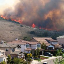
With warmer, drier fire seasons and significant population growth in the wildland-urban interface (WUI), wildfire risk in Austin, Texas is increasing. Wildfire potential exists not just in the more forested portions of west Austin, but all around the city. Though they may exhibit less intensity than west-side crown fires, east-side grass and shrub fires can move extremely fast and pose significant threats to human health and safety, buildings, infrastructure, and water quality.
Austin’s most vulnerable populations largely are concentrated on the east side, a result of early 20th-century segregation policy and the legacy of discriminatory practices. Like other disasters, wildfires disproportionately affect the most vulnerable populations who are more likely to experience adverse outcomes because of their socioeconomic status, race, ethnicity, and age. Vulnerable populations are more likely to lack resources to prepare for, respond to, and recover from disasters, and they may experience cultural and institutional barriers, have limited mobility, and have compromised physical health.
This tool was created to help identify spatial patterns of overlapping vulnerabilities. For example, Austin’s areas with highest population growth nearly all have higher wildfire threat. Wildfire risk intersects with more people who lack proficiency with English, more families in poverty, and more children under the age of 5 in east Austin. A few key east side neighborhoods exhibit multiple intersecting vulnerabilities that are compounded by higher wildfire threat.
Austin’s vision of being a resilient and adaptive city requires a robust understanding of the community’s susceptibility to wildfire risk. This tool can help deepen understanding of where and how Austin’s most vulnerable populations are at the greatest risk to wildfire.
Austin Wildfire and Vulnerable Populations Tool: Resources & Data
- Full Report, including Methods, Data Sources, and User Guide
- Map of Rate of Spread by census tract, from Austin Fire Department Wildfire Division
- Map of Flame Lengths by census tract, from Austin Fire Department Wildfire Division
Related Research
- The Populations at Risk tool generates free reports with socioeconomic information about populations more likely to experience adverse social, health, or economic outcomes due to their race, age, gender, poverty status, or other factors.
- Austin, Texas is part of the Community Planning Assistance for Wildfire program, which works with communities to reduce wildfire risk through improved land use planning.
- Read about the Full Community Costs of Wildfire.
- Explore an interactive map showing Communities Threatened by Wildfire, 2000-2017.