The Wildfire Risk to Communities website—developed by the USDA Forest Service in partnership with Headwaters Economics and Pyrologix—offers maps and data about community wildfire risk nationwide.
Wildfire Risk to Communities is a free, easy-to-use website with interactive maps, charts, and resources to help communities understand, explore, and reduce wildfire risk. Data are available for every U.S. community, tribal area, county, and state.
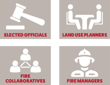
The website is designed to help leaders such as elected officials, community planners, and fire managers understand how risk varies across a state, region, or county, and prioritize actions to mitigate risk.
Wildfire Risk to Communities includes detailed information about wildfire risk to homes, wildfire likelihood, and exposure types, as well as information about vulnerable populations in each community. It also provides resources and tools to help communities reduce wildfire risk.
Background and Partners in Developing Wildfire Risk to Communities
The Wildfire Risk to Communities website was developed by a team led by the USDA Forest Service: National Headquarters – Fire and Aviation Management, and Rocky Mountain Research Station’s Missoula Fire Sciences Laboratory. Headwaters Economics is a partner on the team and provides website design, maintenance, and content development with input from community leaders. Pyrologix, a wildfire threat assessment research firm, develops the map data for the project. Additional partners include Azavea, a mission-driven software and data analytics company that creates the interactive data tools, and Mapbox, which generously provides map tools and hosting.
Wildfire Risk to Communities was created by the USDA Forest Service under the direction of Congress in the 2018 Consolidated Appropriations Act (H.R. 1625, Section 210).
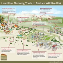
Community Planning Assistance for Wildfire
Wildfire Risk to Communities is a starting point to help answer questions about community risk. The website shares many solutions-oriented resources to help communities reduce and manage wildfire risk. One resource included is the Community Planning Assistance for Wildfire (CPAW) program.
Community Planning Assistance for Wildfire (CPAW) was launched in 2014 by Headwaters Economics and Wildfire Planning International to help communities better plan development in fire-prone landscapes. CPAW works with local fire and land use planning departments to jointly address wildfire risk in the community. In partnership with the USDA Forest Service’s Rocky Mountain Research Station and funded by the Forest Service and private foundations, CPAW provides communities with professional consulting and technical assistance to reduce wildfire risk through improved land use planning. Services and resources are provided at no cost to the communities.
As of 2020, 39 communities in 14 states have participated in the CPAW program, and hundreds more have benefited from CPAW workshops, research, and trainings.
Community Planning Assistance for Wildfire
Community Planning Assistance for Wildfire (CPAW) works with communities to reduce wildfire risk through improved land use planning. The program is a program of Headwaters Economics, in partnership with the USDA Forest Service.