Workshop Description and Summary
In Santa Fe on March 26, 2007, Headwaters Economics conducted a public workshop titled “Know your Social and Economic Situation” for the Santa Fe National Forest.
The goals of the workshop were to involve the public early in the process of developing a new Forest Plan, discuss and understand better the social and economic situation of the area and how it has changed since the last Forest Plan was adopted, and generate reliable and transparent information the Forest Service can use to inform its planning and management.
Summary Documents
Handout 1 – Regional Information (Updated Since Workshop)
Workshop Synopsis and Discussion Notes
Summary of Key Socioeconomic Trends
Population Change – Migration vs. Natural Trends
Maps Illustrating Regional Variability
Economic Profiles from Economic Profile System (EPS)
EPS Profiles contain historical trends from a variety of data sources and are available down to the county level.
State
Aggregated Regional Profiles
7 County Aggregation (Incl. Bernalillo)
Counties
Economic Profiles from Economic Profile System Census (EPSC)
Includes profiles for all county subdivisions in the 6 counties
EPSC (see below) contains more socioeconomic information and is available at smaller geographies (e.g. towns and county subdivisions) but only contains data from the U.S. Census.
State
Counties
County Subdivisions (CCD)
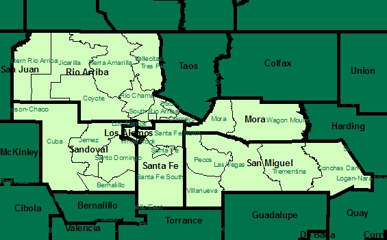
Los Alamos County, NM – Los Alamos CCD
Los Alamos County, NM – White Rock CCD
Mora County, NM – Wagon Mound CCD
Rio Arriba County, NM – Chimayo CCD
Rio Arriba County, NM – Coyote CCD
Rio Arriba County, NM – Dixon CCD
Rio Arriba County, NM – Jicarilla CCD
Rio Arriba County, NM – Rio Chama CCD
Rio Arriba County, NM – Santa Clara Pueblo CCD
Rio Arriba County, NM – San Juan Pueblo CCD
Rio Arriba County, NM – South Rio Arriba CCD
Rio Arriba County, NM – Tierra Amarilla CCD
Rio Arriba County, NM – Vallecitas CCD
Rio Arriba County, NM – Western Rio Arriba CCD
Sandoval County, NM – Bernalillo CCD
Sandoval County, NM – Cuba CCD
Sandoval County, NM – Jemez CCD
Sandoval County, NM – Santo Domingo CCD
Santa Fe County, NM – Santa Fe CCD
Santa Fe County, NM – Santa Fe North CCD
Santa Fe County, NM – Santa Fe South CCD
San Miguel County, NM – Conchas Dam CCD
San Miguel County, NM – Las Vegas CCD
San Miguel County, NM – Pecos CCD
San Miguel County, NM – Trementina CCD
San Miguel County, NM – Villanueva CCD
Profiles for Selected Towns (Census Designated Places)
2002 Census of Agriculture
USDA did not issue a report for Los Alamos County.
