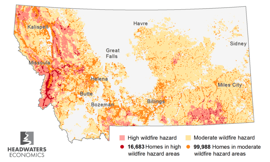
- More than a third of Montana homes—nearly 120,000 homes—have moderate to high wildfire risk.
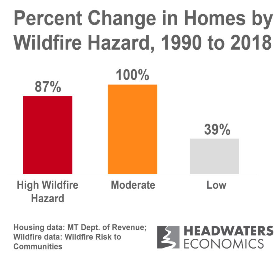
- The number of homes in moderate and high wildfire risk areas has nearly doubled since 1990.
- Wildfire risk spans the state, including the forests of the western region and grasslands and shrublands of the southern and central regions.
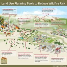
- Land use planning can help reduce wildfire risk by regulating the location and types of development in wildfire hazard areas.
More than a third of Montana homes have moderate to high risk
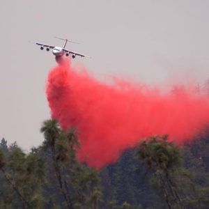
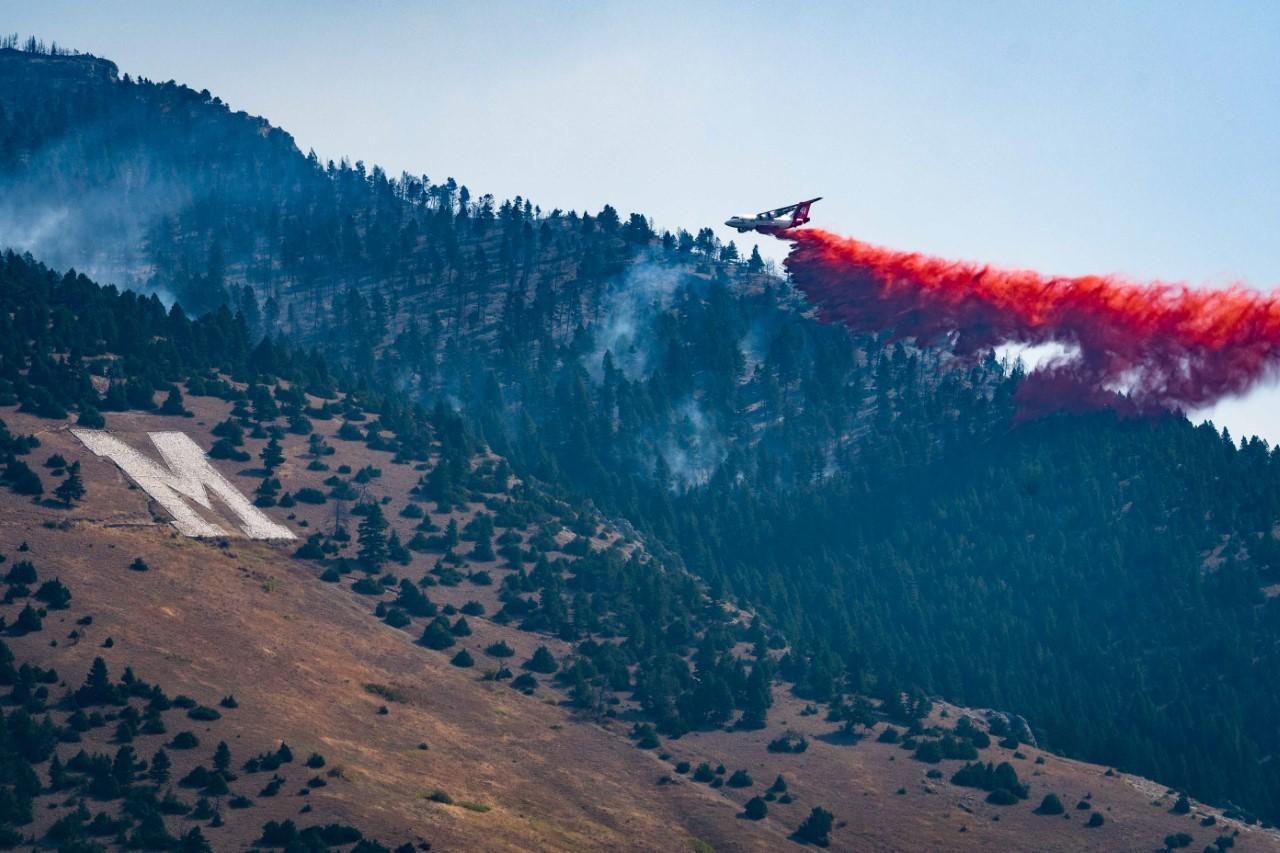
This year’s wildfire season may prove to be one of the state’s most destructive, with over 160 structures lost so far, including 68 in the Bridger Foothills Fire in September. A new analysis of wildfire risk shows that nearly every home in Montana is exposed to some wildfire risk. More than a third of homes—nearly 120,000 homes—are in moderate to high wildfire hazard areas.
Since 1990 the number of homes in moderate to high wildfire hazard areas has nearly doubled. The rate of housing growth in moderate and high hazard areas far outpaces home development in low hazard areas.
The most significant growth occurred in fast-growing Madison County (580% growth in high hazard areas) and Gallatin County (367% growth in high hazard areas).
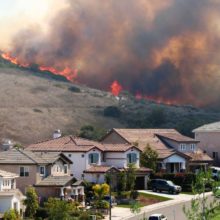
As more people move to Montana, development in wildfire-prone lands is increasing. Drawn by scenic views, recreational opportunities, and surrounding undeveloped lands, housing growth in areas of wildfire hazard is likely to increase. In parallel, wildfire risks to homes and communities will also rise. It is important to anticipate inevitable wildfires and associated risks by planning developments and communities with wildfire in mind.
The wildfire hazard data used in this analysis is derived from the recently released Wildfire Risk to Communities project. Wildfire hazard was compared to the location of new housing developments from Montana Department of Revenue records from 1990 through 2018 to identify where housing development trends and wildfire hazard intersect. (See methods below).
Subscribe to our newsletter!
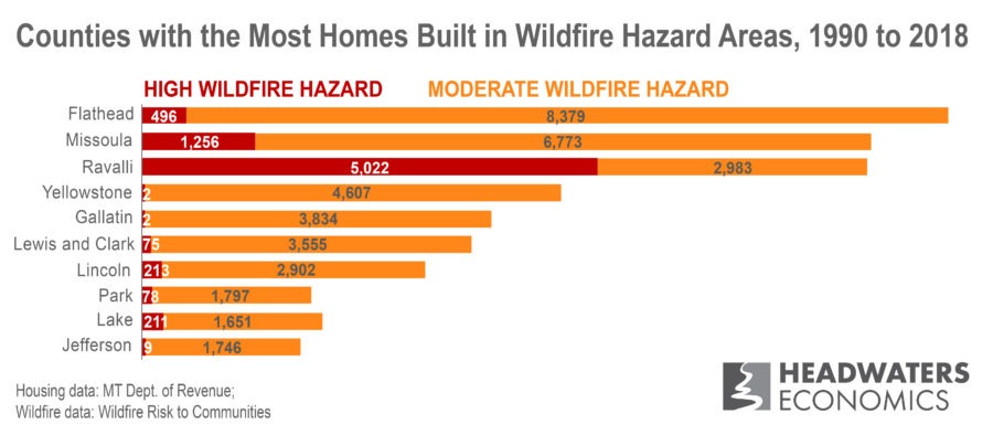
Development in high wildfire hazard areas is concentrated in several counties
Home development in Montana’s high wildfire hazard areas is concentrated in Flathead, Missoula, Ravalli, Yellowstone, and Gallatin counties. This interactive data table shows the number of new homes in each wildfire hazard category for every Montana county.
Places where communities meet or intermingle with wildfire hazard and flammable vegetation is broadly defined as the wildland-urban interface (WUI). The WUI is the fastest-growing land use type in the country and accounts for a third of all homes, growing by 145% between 1992 to 2015. With more structures and people living in the WUI, wildfire risks increase. According to a recent study, humans caused 97% of all wildfires in the WUI and more than doubled the length of the fire season.
Wildfire risk is widespread across the state
Wildfire risk is widespread across the entire state, from forests to grasslands. On average, wildfires in forests account for only 40% of the land area annually burned in the country, while grasslands and shrublands comprise a majority of the burned land. While wildfires in the western part of Montana largely occur in forests, wildfire activity in the southern and central counties occurs in grasslands and shrublands and are some of Montana’s largest wildfire events.
For example, the Lodgepole Complex in 2017 burned more than 270,000 acres near Jordan, scorching valuable rangeland, destroying 32 structures, and nearly 1,400 miles of fencing. In 2019, the North Hills Fire quickly grew to 5,000 acres and forced the evacuation of nearly 500 homes north of Helena.
Grasslands and shrublands provide a very dry but abundant fuel source for wildfires. Wildfires burning in these lands are of low intensity but have a high spread rate. Wildfires occur more often in grasslands and shrublands, accounting for 60% of all wildfires.
Wildfire activity is also very high in the western portion of the state, with the highest risk in and around Missoula. New home development in high wildfire hazard areas increased by 72% in Missoula County, 97% in Ravalli County, and 69% in Mineral County.
Land use planning can reduce wildfire risk
Housing in wildfire hazard areas creates many challenges. Wildfire frequency and extent increase due to human-ignited wildfires, property and lives are exposed to danger, and the cost of fire suppression increases, stretching budgets and resources. The long-term costs of wildfire to a community—such as impacts to health, business and tax revenue, and environmental services—can be decades-long and borne largely at the local level.
Research after wildfires in Montana and elsewhere have shown that home loss is largely dependent on the home’s materials and design, and on mitigation and fuel reduction within the area around the home. To reduce these risks, counties and cities can develop land use planning tools that help determine where and how new housing can be developed. For example, new subdivisions can require set-backs from slopes, vegetation management plans, multiple access roads, and water infrastructure for fire suppression. Building codes can require wildfire-resistant materials and construction techniques in areas where wildfire hazard is higher. Open space plans can help buffer neighborhoods from higher-hazard areas.
Montana’s local governments, fire districts and service areas, and landowners have many opportunities to reduce wildfire risk in the wildland-urban interface through land use planning tools and strategies, though challenges in Montana’s regulatory framework remain. Communities in Montana can learn from approaches in other states and expand the tools available to reduce risk.
Community Planning Assistance for Wildfire (CPAW)—a program of Headwaters Economics—provides resources and tools to better plan the wildland-urban interface. CPAW is working with Missoula, Lewis & Clark, and Park counties to reduce their wildfire risk.


Community Planning Assistance for Wildfire
Community Planning Assistance for Wildfire (CPAW) works with communities to reduce wildfire risk through improved land use planning. The program is a program of Headwaters Economics, in partnership with the USDA Forest Service.
Methods and data sources
Montana housing data are from the Montana Department of Revenue’s Property Assessment Division and were summarized to quarter-section (160 acres) in 1990 and 2018.
Wildfire hazard data are from “Risk to Homes” in Wildfire Risk to Communities—a free, easy-to-use website with interactive maps, charts, and resources to help communities understand, explore, and reduce wildfire risk. It was created by the USDA Forest Service under the direction of Congress with support from the Rocky Mountain Research Station‘s Missoula Fire Sciences Laboratory, Pyrologix, and Headwaters Economics. “Risk to homes” integrates wildfire likelihood and intensity with generalized consequences to a home. It was summarized to the quarter-section and categorized into three classes based on relative hazard: High is the upper 10% of values; Moderate is 40 to 89% of values; Low is the bottom 39% of values.
County-level data
The interactive data table below provides county-level data about housing in each wildfire hazard class. See methods for more information.