- Two out of three survey respondents used trails in the past year. Among those with access to trails, more than half of all their physical activity occurs on trails.
- Three out of four respondents support developing an expanded and better connected trail system in the Taos area, with particular support for infrastructure like wider shoulders and bike lanes to make walking and biking safer.
- Hispanic respondents and low-income respondents are much less likely to have trails and paths within easy walking distance, and much less likely to have bike or pedestrian infrastructure like sidewalks or wide shoulders near their homes. Less access undoubtedly contributes to less use by these groups.
This report supports ongoing efforts in the Enchanted Circle—including Taos County and the towns of Eagle Nest and Angel Fire in Colfax County—to understand the role trails and pathways play in locals’ health and quality of life, and to identify residents’ priorities for improving trail systems for recreation and transportation.
The full survey was prepared by RRC Associates and Headwaters Economics for the Taos Land Trust. It contains reliable information regarding the opinions of a representative sample of county residents, including those who use and do not use trails, a variety of user types, long-time residents and newcomers, locations around the county, and incomes and ages.
Overall Trends in Trail Use and Support
Trails and pathways in the Enchanted Circle are an integral part of daily life and health for many residents. Two-thirds of respondents report using trails in the past year. Trail users report being on the trails two out of three days in the summer and nearly every other day in the winter.
Trails play a significant role in respondents’ physical health, with 56 percent of all trail users’ physical activity taking place on trails.
Most Influential Factors in Residents’ Decision to Move To
Or Stay In the Enchanted Circle
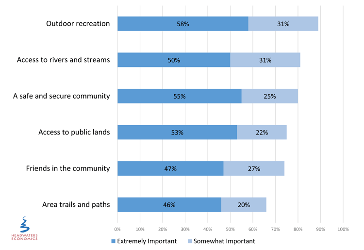
At least half of respondents identify outdoor recreation, access to rivers and streams, living in a safe and secure community, and access to public lands as “extremely important” factors affecting their decision to move to or stay in the Enchanted Circle (see figure above).
These are closely followed by having friends in the community and area trails and paths. While several factors rank higher than trails, trails provide access to the outdoor recreation, rivers and streams, and public lands valued most highly.
Recreation is the most common reason why residents use trails, but non-recreational uses like transportation and maintaining acequias also are among the top five most common uses.
In general, support improving area trails is high: 74 percent of all respondents agree or strongly agree with the statement: “I support the development of an expanded and better connected system of trails and paths in the Enchanted Circle.”
Access to Trails and Use Among Hispanic Residents And Low-Income Residents Is Lower
Forty-five percent of Hispanic respondents have used trails in the previous year compared to 87 percent of non-Hispanics. There is also a significant difference in use between highest- and lowest-income respondents, with 81 percent of the highest income respondents using trails in the previous year compared to 49 percent of the lowest income respondents.
Among those respondents who do use the trails, however, we do not see significant differences in how often they use them in winter or summer, across ethnicity, income, or location of residence. In other words, once residents are on the trails, they use them often.
The differences in trail use may be related to differences in access to trails. On average, Hispanic and low-income respondents are less likely to live within an easy walk of trails or paths, and are less likely to have bike or pedestrian infrastructure like sidewalks and wide shoulders in their neighborhoods.
Difference in Access to Trails, Paths, and Public Lands Between Hispanic and Non-Hispanic Respondents
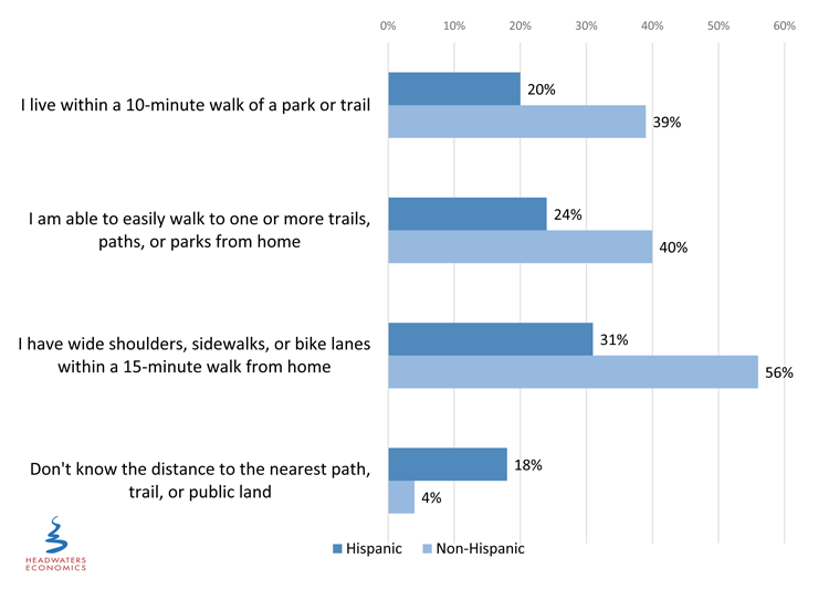
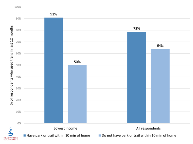
A lack of access has a large effect on the lowest income residents. Among low-income residents who live within a 10-minute walk of a park or trail, 91 percent have used trails within the previous year.
Only 50 percent of low-income residents who do not live within a 10-minute walk of trails used trails in the previous year (see figure below). If low-income residents live close to trails, they use them frequently. Without trails close by, use is dramatically lower.
For comparison, the average respondent who lives within a 10-minute walk of a park or trail is slightly more likely to have used trails in the previous year (78% trail use for those who live nearby compared to 64% trail use for those who do not live nearby).
Trail Use for Those Who Live Close To and Far From Trails,
For Low-Income Respondents and All Respondents
Opportunities to Increase Trail Use
Support for improving and expanding the trail network in the Enchanted Circle is high. However, Hispanic respondents and low-income respondents on average are less likely to be in support, which is consistent with these groups’ lower levels of access and use, and less awareness of trails.
Specific trail-related outreach programs and targeted infrastructure development for Hispanic and low-income residents may help increase use by addressing these residents’ unmet needs.
Hispanic respondents most often identified the following factors as likely to increase their trail use: having trails closer to where they live, hospital- or doctor-sponsored wellness programs such as prescribed exercise, and trail-based programs for kids.
Low-income respondents most often identified the following factors as likely to increase their trail or pathway use: safe separation of bikes and pedestrians from traffic, having trails closer to where they live, and organized activities like guided hikes.
Conclusions
Trail use and support for trails is high, but closer analysis of Hispanic respondents’ and low-income respondents’ preferences reveals important differences.
Hispanic respondents and low-income respondents do not use trails nearly as often, are less likely to support expanding the trails network, and are much less likely to have trails and pathways near where they live. These differences have implications for the effectiveness of strategies to increase trail use and physical activity, and for future support for expanding trails.
These findings suggests that investments in bike and pedestrian infrastructure should identify and prioritize areas that are not well served now.
In addition, low-income residents are more strongly affected than other Enchanted Circle residents when trails are not located in their communities. This may be due to several factors such as having less leisure time or not having access to a vehicle. It also suggests that locating trails in areas with more low-income residents may lead to large gains in trail use and physical activity.
This research also implies that programming and outreach related to trails, such as organized hikes, walking clubs, wellness programs run by medical professionals like prescribed walking, and trail-based programs for kids might be particularly effective with groups who presently use trails less.
To grow a broader base of trail users, trail users can start with more specific community conversations to learn about the reasons behind the patterns observed in this survey.
Initial conversations could focus on learning more about the types of children’s programs and other organized trail activities most likely to interest new users, and the medical based programs that would be most effective at getting otherwise inactive people on the trails.
A recurring theme of a need for improved safety might be addressed by identifying those places that currently are barriers for bike and pedestrian travel using traffic and accident monitoring data, particularly around connections to schools and between neighborhoods. Conversations with residents would also reveal places that are perceived as unsafe and ways to change these perceptions.
While these results show significant variation between different groups of Enchanted Circle residents, overall people are using the trails regardless of ethnicity, income, or location of residence. Targeting trail-related programs and infrastructure investments will further increase trail use and support.
Methods
This survey was conducted in Winter, 2016 using three primary methods: 1) a mail-back survey, 2) an online, invitation-only web survey to further encourage response from those residents already within the defined invitation sample, and 3) an open-link online survey for members of the public who were not part of the invitation sample.
A total of 3,000 surveys were mailed to a random sample of Taos County residents in January 2016. The final sample size for the statistically valid survey (with responses either via mail survey or online survey) was 265; the open link survey received an additional 99 responses. Due to the relatively small sample size and similar response patterns between the two samples, the invitation survey and open link survey results are combined and discussed in aggregate throughout the report. This combined sample of 364 has a margin of error of approximately +/- 5.1 percentage points for questions at 50 percent response.
Lowest income respondents are those who report an annual household income of $25,000 or less (30% of the sample).
The LOR Foundation, whose goal is to enhance livability and quality of life in the Intermountain West through community-driven solutions, provided funding for this research to help communities better understand the use of trails and pathways, and to make informed choices about investing in and managing this infrastructure.
