Utilizing a statistical model, Headwaters Economics created an interactive map to show the amount of per capita income explained by protected federal lands for each county in the non-metropolitan western U.S.
For example, in Gallatin County, Montana $2,655 of the per capita income (7% of total PCI) can be explained by the presence of protected public lands.
The new interactive map takes into account each county’s characteristics and shows an estimated amount of per capita income that can explained by protected federal lands for each non-metropolitan county.
This new county-specific analysis builds on earlier work (West Is Best) by Headwaters Economics that looked at the U.S. West’s 286 non-metro counties as a region, and found a meaningful relationship between the amount of protected public land and higher per capita income levels in 2010. According to this analysis, the effect protected public lands have on per capita income can be most easily described in this way: on average, western non-metro counties have a per capita income that is $436 higher for every 10,000 acres of protected public lands within their boundaries.
Full Study and Citation
The full study found that three economic measures were positively associated with protected public lands: per capita income (2010), growth in per capita income (1990-2010), and growth in per capita investment income (1990-2010). It is available as a manuscript and should be cited as: Rasker, R., P.H. Gude, M. Delorey. 2013. The effect of protected federal lands on economic prosperity in the non-metropolitan West. Journal of Regional Analysis and Policy.
Methods
To develop county-specific estimates for the amount of per capita income that can be explained by protected federal lands, metropolitan counties were excluded since their economies are large enough that we would not expect the presence of protected lands to be an important driver of their economic activity. Ten economic variables then were selected as being representative of overall county economic health:
- Per Capita Income (2010)
- Average Earnings Per Job (2010)
- Change in Per Capita Income (1990-2010)
- Change in Per Capita Investment Income (1990-2010)
- Change in Per Capita Age-Related Non-Labor Income (1990-2010)
- Migration (1990-2010) divided by 1990 Population
- Change in Percent of Adults with College Education (1990-2010)
- High Wage Services (2010) / High Wage Services (1998)
- Total Employment (2010) / Total Employment (1990)
- Total Income (2010) / Total Income (1990)
Acres of protected public land and the sum of the acreage of protected public land in adjacent counties were obtained for each county in the study. We adopted the definition of “protected public lands” from Rasker et al. (2009), in which specific federal land designations of the National Park Service (NPS), the Forest Service (FS), the Bureau of Land Management (BLM), or the U.S. Fish and Wildlife Service (FWS) were considered protected. These designations are:
- National Parks and Preserves (NPS)
- Wilderness (NPS, FWS, FS, BLM)
- National Conservation Areas (BLM)
- National Monuments (NPS, FS, BLM)
- National Recreation Areas (NPS, FS, BLM)
- National Wild and Scenic Rivers (NPS, FS, BLM)
- Waterfowl Production Areas (FWS), Wildlife Management Areas (FWS)
- Research Natural Areas (FS, BLM), Areas of Critical Environmental Concern (BLM)
- National Wildlife Refuges (FWS)
Lands administered by other federal agencies (including the Army Corps of Engineers, Bureau of Reclamation, Department of Defense, Department of Energy, and Department of Transportation) were not included, nor were state, local, or private lands. This definition of protected public lands attempts to include areas that have a higher level of managerial and commercial use restrictions than other federal lands and a less changeable status than other designations (for example, Wilderness Study Areas and Inventoried Roadless Areas).
Additionally, six variables were identified as possibly confounding associations between the protected public land variables and the economic variables:
- Acres of Unprotected Public Land
- Change in Percent of Jobs in Mining (1998-2010)
- Change in Percent of Jobs in Timber (1998-2010)
- Average Variation in Elevation
- Percent of Area that is Surface Water
- Travel Time to the Nearest Major Airport
The county specific estimates were generated using a single model to regress the vectorized matrix of economic indicators on protected public land variables and suspected confounding variables using generalized estimating equations (GEEs) and assuming a normal distribution. Protected public land variables were converted into a percent by dividing by the total number of acres either in the county or in the neighboring counties, as appropriate. Three of the economic variables, High Wage Services 2010 / High Wage Services 1998, Total Employment (2010) / Total Employment (1990), and Total Income (2010) / Total Income (1990), were log-transformed prior to performing the regression. A random effect for county was included in the model and variances for each economic indicator were allowed to vary.
This model is simpler than that described in the full study which treated the protected public land variables as random rather than fixed variables but could not be used to quantify the proportion of per capita income accounted for by protected public lands for individual counties. The simpler GEE model does not capture uncertainty contained in the protected public lands variables and may underestimate total variance. However, the model yields unbiased estimates of marginal means, and is appropriate for use to gain understanding of how protected public lands effect individual counties.
Interpretation
Looking at the U.S. West’s non-metro counties together, the effect protected public lands have on per capita income can be most easily interpreted in this way: on average, western non-metro counties have a per capita income that is $436 (95% Confidence Interval: $115 to $758) higher for every 10,000 acres of protected public lands within their boundaries. This relationship is further explained in both the Headwaters Economics “West Is Best” report (see Page 20) and in the report manuscript.
Beyond this trend for the non-metro West, the interactive map shows the estimated amount of per capita income explained by protected public lands for each county. Importantly, these county level estimates adjust for county by county differences in the presence of other public lands, the presence of natural amenities, the degree of access to markets, the growth or decline in commodity sectors, and the presence of protected public lands in neighboring counties. In other words, we used the statistical model described above to generate the mapped estimates rather than assuming that the average relationship ($436 per 10,000 acres) holds true regardless of the county’s other characteristics.
While our analysis shows a clear positive relationship between protected public land and per capita income, as with other observational studies, causality cannot be implied. Humans are adaptable and their decisions are influenced by many factors. A county with 10 percent of its per capita income explained by protected lands would not necessarily have a 10 percent lower per capita income had those protected lands never been designated. However, across the West, evidence shows that, on average, counties with more protected lands have higher per capita income.
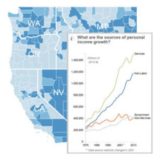
One of the reasons for this positive relationship may be that in today’s economy, a premium is placed on the ability of communities to attract talented workers, and the environmental and recreational amenities provided by national parks and other protected lands serve to attract and retain talented people who earn above average wages, and have above average wealth, such as investment income. This explanation would be consistent with the non-metro West’s transition into a service-based economy, which constitutes 61 percent of all employment. It is also consistent with the rapid growth of non-labor income in the non-metro West, including retirement and investment income, which has comprised 65 percent of net total personal income growth in the last decade. For a more detailed discussion of the issues raised in this paragraph, see the Headwaters Economics “West Is Best” report.
Importantly, the positive association we found between economic growth and protected public lands does not mean that protected public lands always lead to fast-growing economies. Several studieshave shown that natural amenities may be an important but not sufficient condition for growth. Also needed are other factors, such as an educated workforce and access to major markets via transportation infrastructure, such as airports.
In addition, some of the literature on the role of protected public lands has pointed to negative effects resulting from amenity migration. Some of the consequences of people moving to the countryside are: urban sprawl; encroachment of residential areas onto fire-prone lands, also known as the wildland-urban interface; a disruption of wildlife migration patterns and habitat; and loss of biodiversity. In other words, economic growth itself is not without its challenges.
Under the right circumstances, including an awareness and willingness to manage economic growth and residential development, protected public lands such as wilderness and national parks can be a significant economic boost to the non-metropolitan counties of the West.