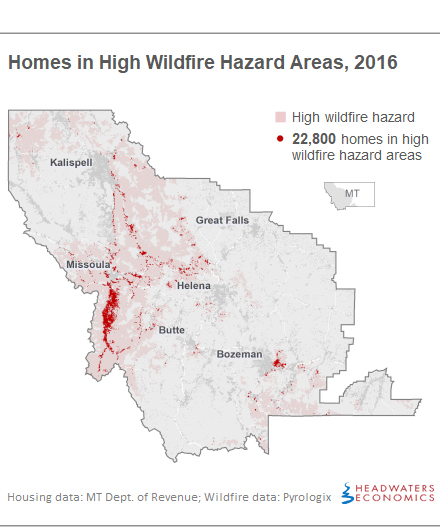
- More than 11,000 new homes—one in eight of all new homes—were built in areas with high wildfire hazard in western Montana during the last 26 years.
- Homes in areas with high wildfire hazard doubled, outpacing development rates in areas with low wildfire hazard. These trends are most pronounced in a handful of western Montana counties.
- A continuation of current housing trends in wildfire-prone areas will increase fire suppression liabilities by $4 million each year, putting lives and property in danger.
- Strategic and thoughtful land use planning can help reduce wildfire risks and costs.
Thousands of Homes Have Been Built in High Wildfire Hazard Areas
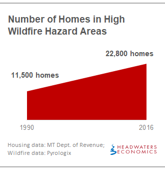
Since 1990 in western Montana, the number of single-family homes built in high wildfire hazard areas has doubled, growing from 11,500 to 22,800 homes. More than 11,000 new homes have been built in areas with high wildfire hazard, averaging nearly 450 per year. This represents one in eight homes constructed in western Montana. During the same period, another 17,000 homes were built in areas of moderate wildfire hazard.
Although most of western Montana is prone to wildfire, certain areas have higher hazard due to fuels, topography, weather, and ignition patterns. When homes are added to these landscapes, the risks and costs increase.
This trend is not limited to western Montana. Nationally, the wildland-urban interface (or the area where houses and wildland vegetation meet or intermingle) is the fastest-growing land use type. This development pattern puts lives and property at risk, increases the difficulty and expense of fighting fires, and often results in more human-ignited wildfires.
Montana’s 2017 wildfire season was the state’s worst on record, with more than one million acres burned and 141 structures destroyed. It cost more than $400 million, setting a record-breaking $74 million in state liability.
The wildfire hazard data used for this study is from an assessment completed by Pyrologix for the U.S. Forest Service Northern Region. Hazard is delineated into three classes: high, moderate, and low. Expected wildfire hazard was compared to the location of new housing developments from Montana Department of Revenue records from 1990 through 2016 to identify where housing development trends and wildfire hazard intersect. (See Methods and Data Sources).
A Handful of Counties Are Driving Development in Wildfire Hazard Areas
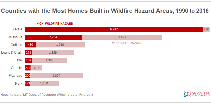
Eight counties —Ravalli, Missoula, Gallatin, Lewis & Clark, Lake, Granite, Flathead, and Park—account for 96 percent of the new houses in areas of high wildfire hazard in western Montana. Ravalli County and Missoula County saw the most growth in areas of high wildfire hazard, together accounting for 82 percent of the housing growth in areas of high wildfire hazard.
This interactive data table is sortable by county, number of homes in wildfire hazard areas in 2016, and number of new homes since 1990.
Development Is Happening Faster in Wildfire Hazard Areas
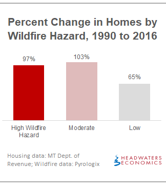
Across western Montana, the number of homes in areas with more wildfire hazard is growing significantly faster than areas with low hazard.
Since 1990, the number of homes in areas of high wildfire hazard has nearly doubled. The same is true for areas of moderate wildfire hazard, where home construction has increased by 103 percent from 16,800 to 34,000. By comparison, areas of relatively low wildfire hazard have experienced a 65 percent increase in home construction.
People who build homes in western Montana are often attracted to forested areas with large lots. The attraction of living in a natural Montana setting has resulted in a rapid pace of development in high wildfire hazard areas. Not many Montana counties have incorporated wildfire into their land use planning programs to help guide where and how development can occur in wildfire hazard areas.
Homes Increase the Cost of Firefighting
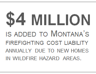
The fire suppression cost liability will increase by at least $4 million every year if the rate of western Montana home construction continues at its current pace of 450 homes built annually in high wildfire hazard areas.
This conservative estimate is based on a Montana study that found that each additional home within one mile of a wildfire is associated with a $9,000 increase in suppression costs. The estimate is extremely conservative for two reasons: (1) Recent studies in Oregon and northern California show higher firefighting costs associated with new homes, particularly in low-density development patterns; and (2) wildfire suppression costs are a small share of the overall cost burden. Across the United States, the increasing cost and risk of wildfire are tied to housing growth in the wildland-urban interface. Between 50 and 95 percent of firefighting costs are estimated to be attributable to the defense of private property.
In 2017, nearly 3,000 Montana homes were within one mile of that year’s wildfires, which increased suppression costs by at least $25 million that year.
Land Use Planning Can Reduce Risk
Housing in wildfire hazard areas creates many challenges. Wildfire frequency and extent increase due to human-ignited wildfires, property and lives are exposed to danger, and the cost of fire suppression increases, stretching budgets and resources. The long-term costs of wildfire to a community—such as impacts to health, business and tax revenue, and environmental services—can be decades-long and borne largely at the local level.
Research after wildfires in Montana and elsewhere have shown that home loss is largely dependent on the home’s materials and design, and on mitigation and fuel reduction within the area around the home. To reduce these risks, counties and cities can develop land use planning tools that help determine where and how new housing can be developed. For example, new subdivisions can require set-backs from slopes, vegetation management plans, multiple access roads, and water infrastructure for fire suppression. Building codes can require wildfire-resistant materials and construction techniques in areas where wildfire hazard is higher. Open space plans can help buffer neighborhoods from higher-hazard areas.
Montana’s local governments, fire districts and service areas, and landowners have many opportunities to reduce wildfire risk in the wildland-urban interface through land use planning tools and strategies, though challenges in Montana’s regulatory framework remain. Communities in Montana can learn from approaches in other states and expand the tools available to reduce risk.
Community Planning Assistance for Wildfire (CPAW)—a program of Headwaters Economics—provides resources and tools to better plan the wildland-urban interface. CPAW is working with Missoula, Lewis & Clark, and Park counties to reduce their wildfire risk.
Methods and Data Sources
See this document for complete methods and data sources. Western Montana housing data are from the Montana Department of Revenue’s Property Assessment Division and were summarized to quarter-section (160 acres) for a previous study that examined housing growth rates across the state.
Wildfire hazard data are from an October 2017 assessment completed by Pyrologix for the U.S. Forest Service Northern Region. Wildfire hazard data are derived from wildfire simulation modeling that incorporates the likelihood of a wildfire burning, the intensity of a wildfire if it were to occur, and the generic susceptibility of a structure to those intensities. It was summarized to the quarter-section and categorized into three classes based on relative hazard: High is the upper 20 percent of values; Moderate is 50 to 80 percent of values; Low is the bottom 50 percent of values.
We limited our analysis to 25 counties in western Montana because this was the only area in Montana for which contiguous wildfire hazard data was available.
New Montana Homes Increase Wildfire Risks, County Level Data
Columns labeled “total” include the number of homes in each wildfire hazard type (high, moderate, and low) in 2016. Columns labeled “new” include the number of new homes constructed between 1990 and 2016. See Methods and Data Sources.
